
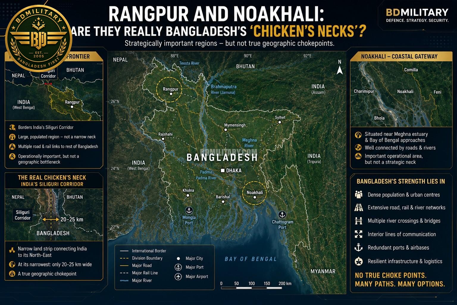
As Bangladesh modernises its armed forces and pursues a more diversified foreign and defence policy, discussions surrounding the country’s strategic geography have become increasingly prominent. Among the recurring assertions is that Bangladesh possesses two so-called “chicken’s necks”—Rangpur in the north-west and Noakhali in the south-east—which are sometimes portrayed as decisive vulnerabilities in any future conflict.
Such descriptions are attractive because they simplify complex geography into easily understood concepts. However, when examined through the lens of military geography and modern warfare, the comparison proves to be misleading.
What Constitutes a “Chicken’s Neck”?
In strategic studies, a “chicken’s neck” is a narrow strip of territory whose disruption could physically isolate or divide a country. Such terrain becomes a strategic chokepoint because it carries the majority of a nation’s communications, logistics and military reinforcement routes.
The classic South Asian example is India’s Siliguri Corridor. At its narrowest point, the corridor is only around 20–25 kilometres wide and represents the principal land connection between mainland India and its eight northeastern states. A major disruption there would significantly complicate India’s ability to reinforce or sustain forces in the region.
The vulnerability stems from geography rather than population density.
Rangpur: A Strategic Frontier, Not a Geographic Bottleneck
Rangpur Division occupies an important position adjacent to India’s Siliguri Corridor. Its proximity naturally ensures that it features in military planning on both sides of the border.
Nevertheless, Rangpur does not possess the defining characteristics of a strategic chokepoint.
Unlike the Siliguri Corridor, Rangpur is not a narrow land bridge connecting two separated parts of Bangladesh. Instead, it comprises a broad region consisting of multiple districts, extensive road and rail networks and several north-south and east-west axes of communication.
Military operations in Rangpur would undoubtedly influence the northern theatre, but control of the region would not sever Bangladesh into isolated sectors or prevent the movement of forces elsewhere in the country.
Its importance is therefore operational rather than geographical.
Noakhali: A Key Coastal Approach Rather Than a “Neck”
A similar argument is occasionally made regarding Noakhali.
Situated near the Meghna estuary and the approaches to Chattogram, Noakhali occupies an important location within Bangladesh’s coastal defence architecture.
Its strategic relevance derives from:
- Access to the Bay of Bengal.
- Proximity to major maritime approaches.
- Connections between Dhaka and south-eastern Bangladesh.
- Influence over surrounding river networks.
These factors make the area an important operational theatre.
However, Noakhali is neither narrow nor isolated. It is densely populated and supported by multiple highways, river transport routes and alternative lines of communication. Even in wartime, the region does not function as a single corridor whose loss would divide the country.
It is therefore more accurately described as a coastal operational gateway than a strategic bottleneck.
Why Do These Areas Receive Attention?
Military planners evaluate terrain differently from civilian geographers.
Rather than asking whether an area is narrow, they ask:
- Where are the major bridges?
- Which roads carry military logistics?
- Which terrain channels armoured movement?
- Where are the critical command centres?
- Which river crossings determine operational tempo?
From this perspective, Rangpur and Noakhali remain highly significant because they influence manoeuvre, surveillance and logistics. That operational importance, however, should not be confused with the existence of a geographic chokepoint.
Bangladesh’s Real Strategic Geography
Bangladesh presents a unique operational environment.
The country’s defining geographic characteristic is not narrow territory but an extensive network of rivers, floodplains and densely populated urban centres.
Military mobility depends heavily upon:
- The Jamuna River crossings.
- The Padma River crossings.
- The Meghna bridge network.
- National highways.
- Railway junctions.
- Inland logistics hubs.
- Chattogram Port.
- Mongla Port.
- Airbases and fuel depots.
These critical nodes have far greater operational significance than the width of any individual district.
The temporary loss of a major bridge or logistics hub could have a more immediate effect on military operations than the occupation of a relatively large area of territory.
Strategic Depth in a Compact Country
Bangladesh is often described as geographically compact, but compactness should not be confused with strategic fragility.
Strategic depth is determined not only by physical distance but also by the resilience of national infrastructure, the density of communications networks and the ability to sustain military operations.
Bangladesh possesses several characteristics that enhance resilience:
- Dense road and railway networks.
- Numerous alternative river crossings.
- Multiple ports.
- High urban density.
- Interior lines of communication linking major population centres.
These characteristics provide redundancy that reduces dependence on any single route.
Lessons from Modern Warfare
Recent conflicts have demonstrated that strategic geography is no longer defined solely by narrow corridors.
The wars in Ukraine, the Caucasus and the Middle East have highlighted the growing importance of:
- Long-range precision strike.
- Armed unmanned aerial systems.
- Integrated air defence.
- Satellite intelligence.
- Electronic warfare.
- Cyber operations.
- Dispersed logistics.
Modern militaries seek to degrade command-and-control systems, transportation infrastructure and logistics networks rather than simply seize narrow strips of territory.
Consequently, resilient infrastructure has become as important as geography itself.
The Infrastructure Challenge
If Bangladesh possesses strategic vulnerabilities, they are more likely to be found in critical infrastructure than in territorial bottlenecks.
Major bridges, railway junctions, ports, fuel storage facilities, power generation and communications networks represent assets whose disruption could have nationwide operational consequences.
Protecting and rapidly restoring these systems is therefore likely to be more important than defending any supposed “chicken’s neck”.
Why the Narrative Persists
The description of Rangpur or Noakhali as Bangladesh’s “chicken’s neck” appears to arise from an understandable but imperfect application of strategic terminology.
Both regions are undoubtedly important in operational planning because of their proximity to international borders, maritime approaches and major transportation corridors. They are natural areas of focus for military planners.
However, operational significance should not be mistaken for geographic vulnerability.
Unlike India’s Siliguri Corridor, neither region constitutes a narrow land bridge upon which Bangladesh’s territorial integrity depends.
Strategic Assessment
Bangladesh’s military geography differs fundamentally from that of countries whose security depends on a single narrow corridor.
Its principal challenges lie in safeguarding critical infrastructure, maintaining resilient logistics and ensuring freedom of manoeuvre across a riverine battlespace.
As the Bangladesh Armed Forces continue to modernise with improved mobility, integrated air defence, precision fires and enhanced command-and-control capabilities, the country’s resilience will increasingly depend on the redundancy of its infrastructure and the adaptability of its forces rather than on the defence of any single geographic corridor.
Concluding Remarks
The comparison between Rangpur or Noakhali and India’s Siliguri Corridor oversimplifies Bangladesh’s strategic geography.
Both regions are important operational theatres and would almost certainly feature prominently in military planning. However, neither satisfies the defining characteristics of a classical strategic chokepoint.
For Bangladesh, the decisive factors in any future conflict are unlikely to be the defence of a mythical “chicken’s neck”. Instead, success would depend upon protecting critical infrastructure, maintaining resilient logistics, preserving command-and-control networks and exploiting the country’s dense transportation system and riverine terrain.
Understanding this distinction provides a more accurate assessment of Bangladesh’s strategic geography and reflects the realities of twenty-first century warfare, where infrastructure resilience and operational mobility have become as important as the map itself.

Khaled Ahmed is a seasoned former intelligence analyst and military expert from the Netherlands, bringing over 15 years of specialised experience in operational intelligence, threat analysis, and strategic defence planning. Having served in high-level, classified roles within Dutch military intelligence, he possesses rare expertise in European security architecture, NATO doctrine, and asymmetric warfare. Khaled’s deep operational insight and international perspective enable him to deliver precision-driven intelligence analysis and forward-looking strategic forecasts. A trusted contributor to high-level risk assessments and security briefings, he offers readers clarity on complex defence and security challenges. Khaled leads the National Security and Fact Analysis sections at BDMilitary. He holds a Master’s degree in International Relations from the University of Groningen, The Netherlands, and is fluent in Dutch, French, and Arabic — combining linguistic dexterity with operational expertise to analyse security issues across cultures and regions.